About Sailaway
Sailaway III
Sailaway III is a virtual sailing environment. A realistic simulation of sailing in all it's complexity. With virtual sailboats, saling clubs, online races and actual weather conditions.
The MMO open world has the same size and shape as the real world. This also means that the sailing distances are the same as in the real world. Sailing from Europe to the US will take several weeks. But don't worry, because when you log off, your boat will continue to sail to the next waypoint
A multiplayer game for sailing where you may encounter other boats, sail together or compete against others in races. There is an active and welcoming community of enthusiastic sailors, who not only organize races, but also non-competitive events like flottiljas.
Realism
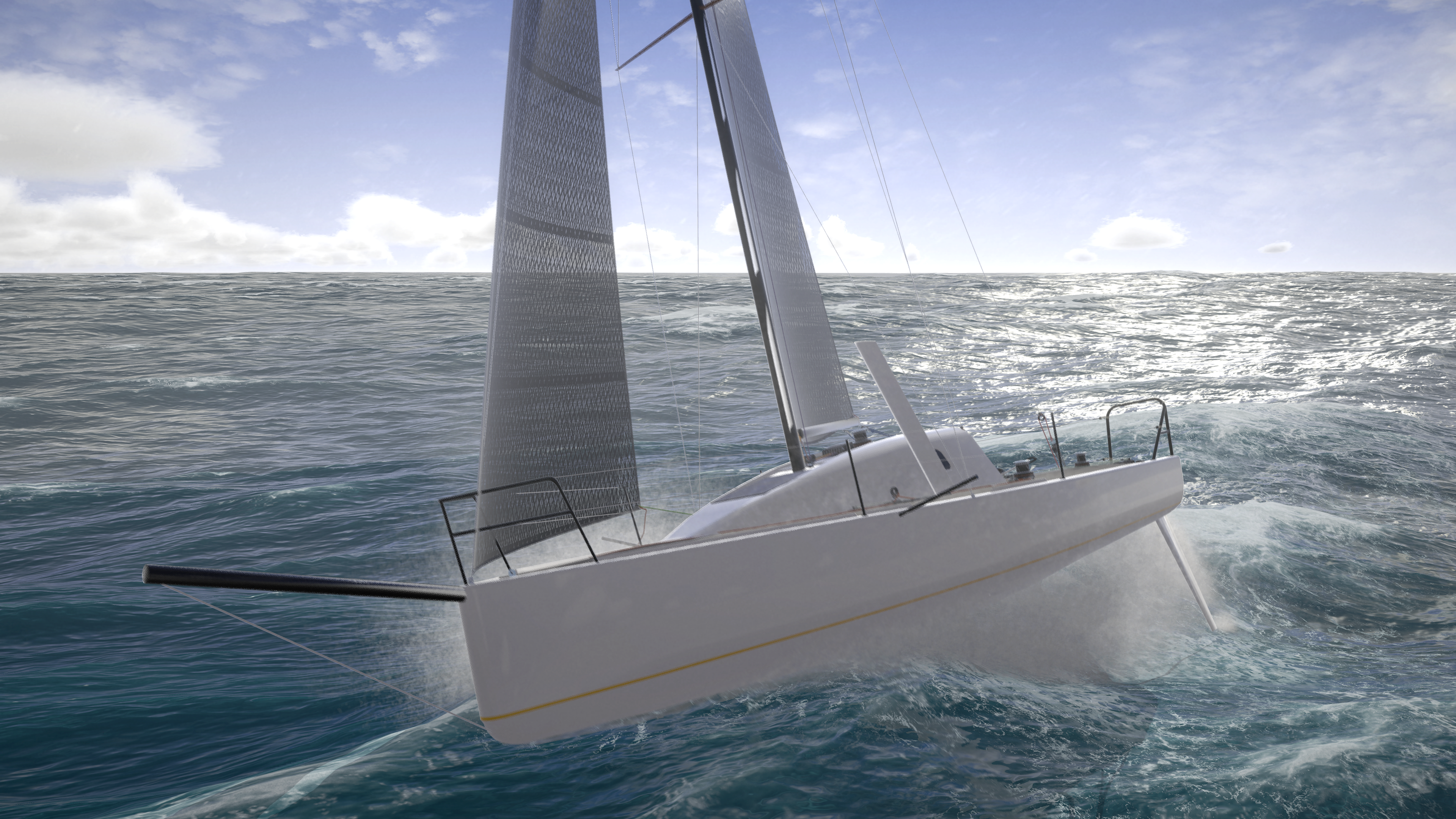
The physics of your boat are simulated are realistic as possible. Hydrodynamics determine your boat's behavior in the waves and airodynamics determine the flow of the air in your sail and the power it produces. You can visualize this air flow to learn and experiment with the trim lines. Those trim lines can even be customized.
During your journey, you will experience the same weather and the same local time as the real world at that location. When it storms in the real world, there will be a storm with dark clouds and huge waves in the virtual world as well. And when there is no wind in the real world, your boat will float helplessly in the vast ocean waiting for a breeze. Or you may find your boat in the middle of a dark night. Unllike in Sailaway II, these conditions can be temporarily altered, but where is the fun in that? Read more...
Tidal waterlevels are automatically applied everywhere you go. With a bit of help from the sailing community the tidal currents will be applied as well. Read more...
There is now a non-GPS mode in which the sailor has to rely on a magnetic compass and celestial navigation. The magnetic compass points to the magnetic north.
Food and water provisions are kept and reduced daily according to the temperature and weather conditions. Taking in a lot of food and water will the boat heavier and slow it down. Underwater growth is also gradually added on your journey and will have a negative effect on boat speed as well.
Educational
Many people without any sailing experience have become true sailors by learning the basics of sailing in Sailaway. There is even a public school that uses Sailaway to educate the children in sailing. But also experienced sailors improved their sailing skills with Sailaway. It helps them with a better understanding of sail trim and tactics through practice.
The position of the sun, moon, planets and stars is simulated accurately for the position of your boat and the time. In non-GPS mode you need to use the sextant to compute your position and progress.
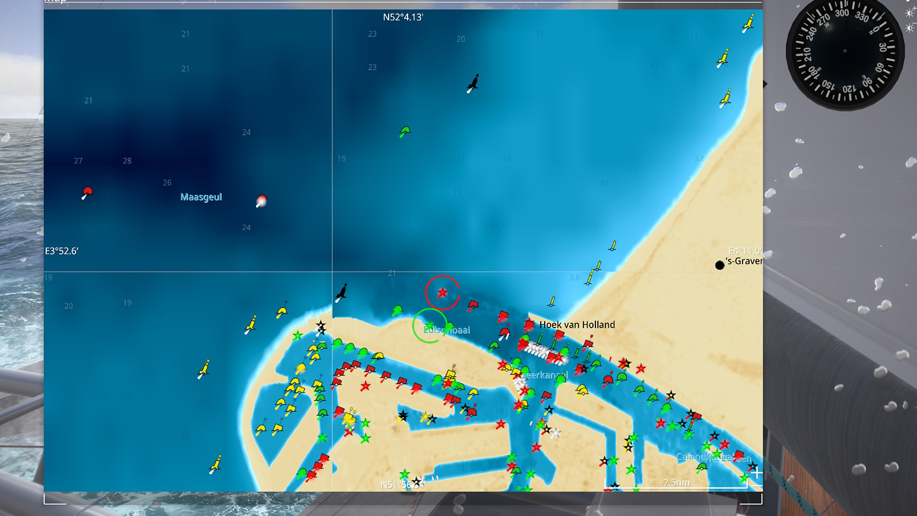
The buoys, lights and other seamarks of the real world are also present in the virtual environment of Sailaway. You will find the coastal waters at night filled with the rhythmic flashing of red, white and green lights according to their light signatures. They are a perfect way to practice your navigation skills.
Sail trim
The flow of air along the sails is computed and simulated in real-time. There is no ideal setting, no hidden presets, nothing like that. If you want your boat to go fast, you need to trim the sails to give maximum power, while maintaining a laminar flow at an ideal angle. Just like in the real world. With one important difference: In sailaway you can make the air visible and actually see how it flows around your sails.
This creates a unique experience and a fantastic learning environment. You can experiment as much as you like with different line tensions, different deck layouts and even differently cut sails.
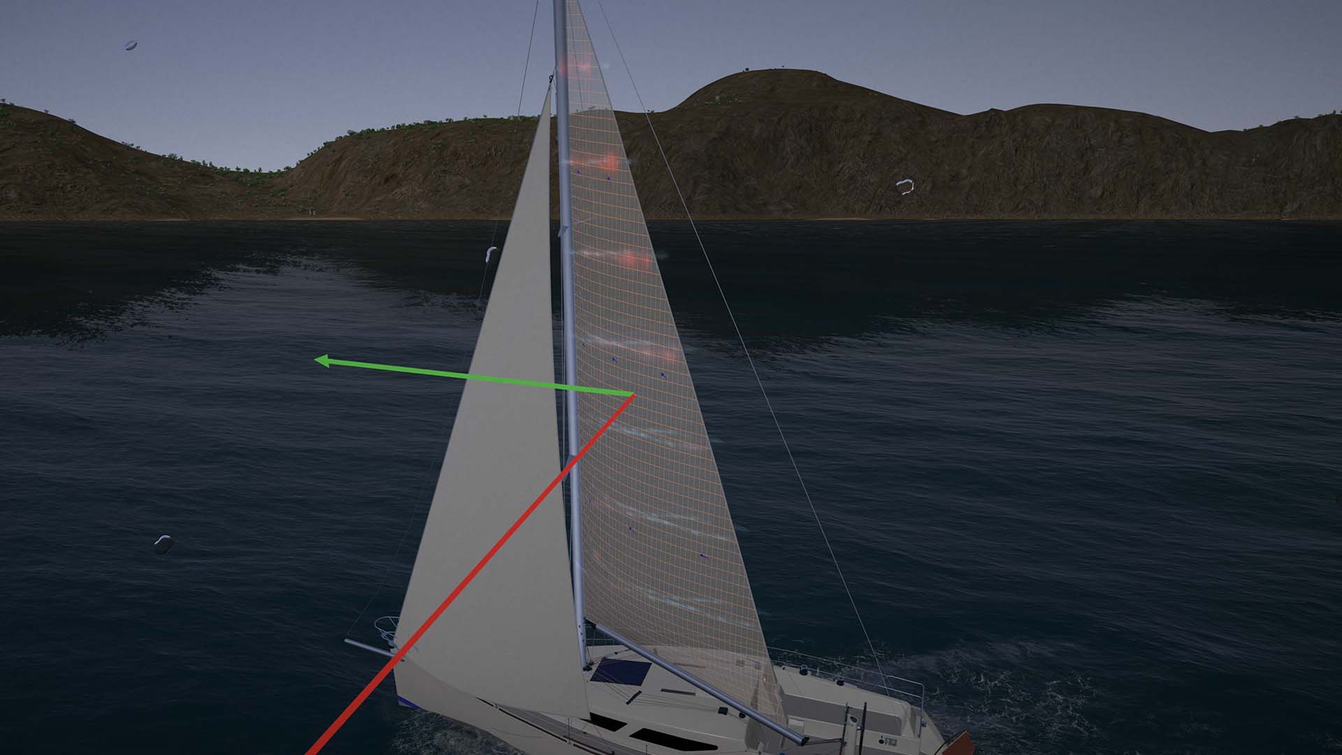
Leech is too tight and bottom curve too far forward. Ease the vang or pull the traveller to starboard, ease the cunninghamhole a bit as well.
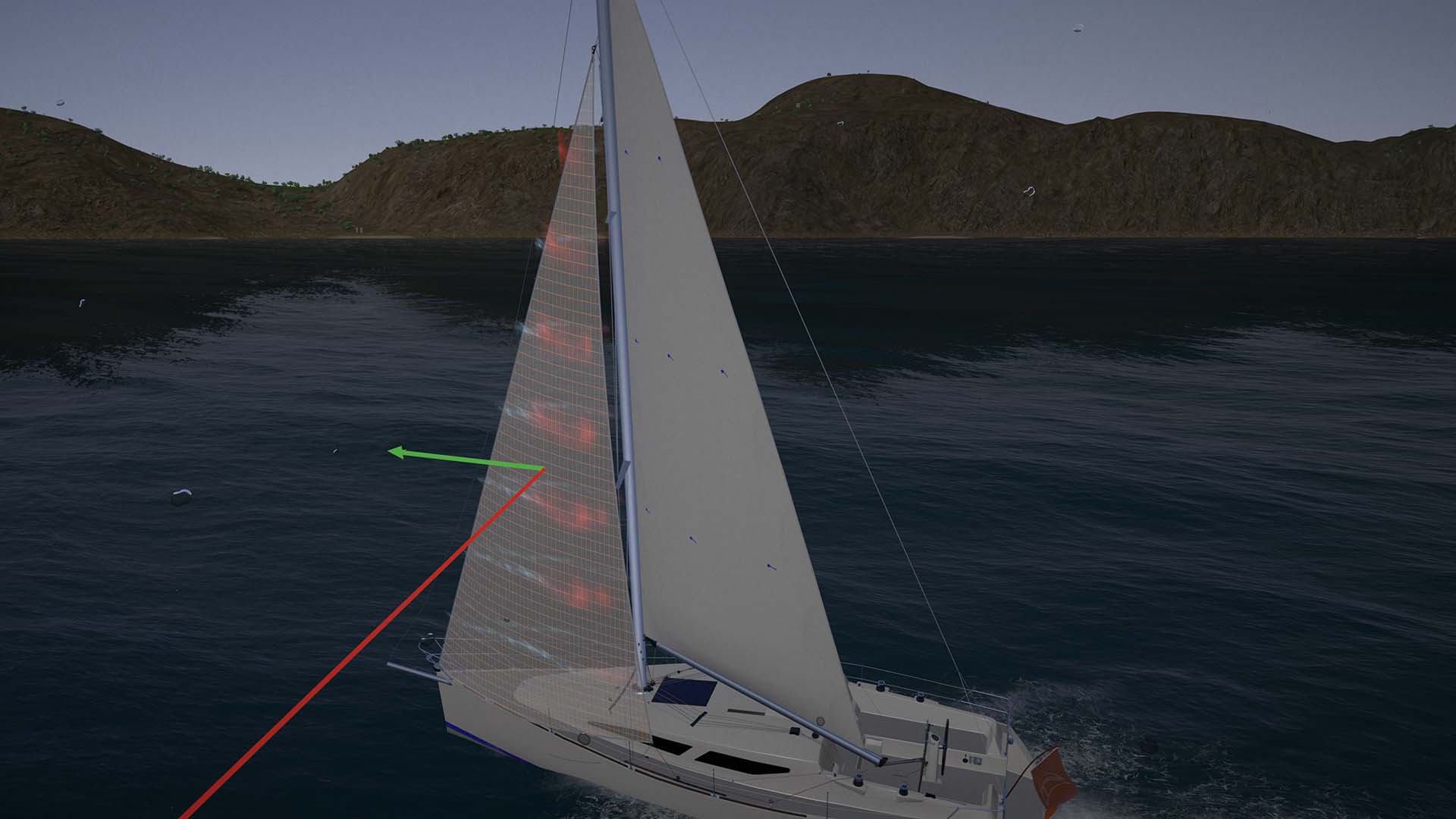
Top is too tight. Ease the leadcar back and play with the sheet.
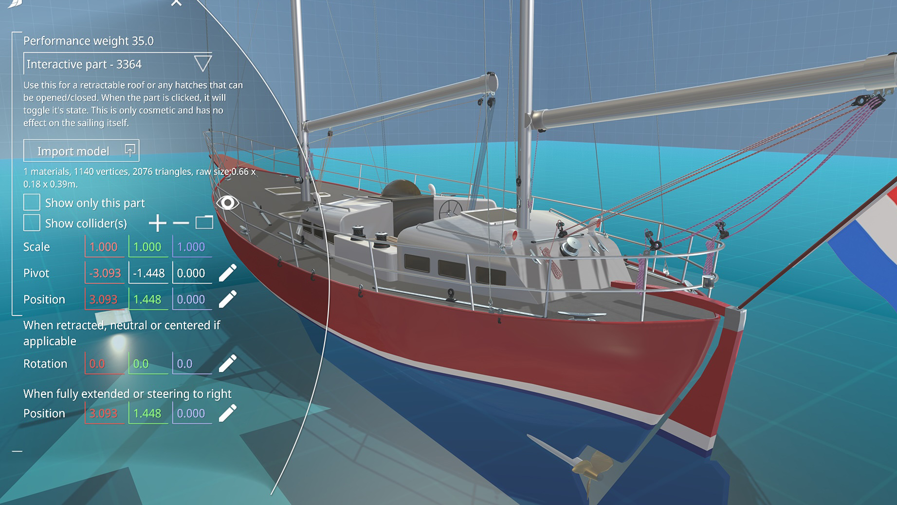
Boat designer
Sailaway III comes with an advanced boat designer. You can upload and create a 3D model of your dream boat and Sailaway will fill in the hard bits.
A boat has many moving parts and those moving parts may in turn have other moving parts attached to them. The boat designer takes care of this and makes sure that everything behaves naturally and in accordance with the sail settings and the trim of the boat.
The sail designer makes sure your sails will function like you would expect.
Sailaway does the math needed to predict the behaviour and speed of the boat. It incorporates the actual forces in the sails, the water drag, wind drag, the lift generated by the hull, the sails and the foils, rudder drag, etc. Every force that also operates on a real boat is taken into account and results in speed, heel, lift and maneouvrability.
When sailing online, speeds are not based on predefined polar diagrams like in other games. It's the other way around. Polar diagrams are based on the speed data that is gathered while you sail.
When sailing offline, these intense physics computations can't be made in real time. Boat speeds for offline sailing will be custom for your boat and your skills. To make your boat go faster when you sail offline you need to "train" it (and yourself) by trying to sail as fast as possible, while Sailaway records your data in your personal polar diagrams.
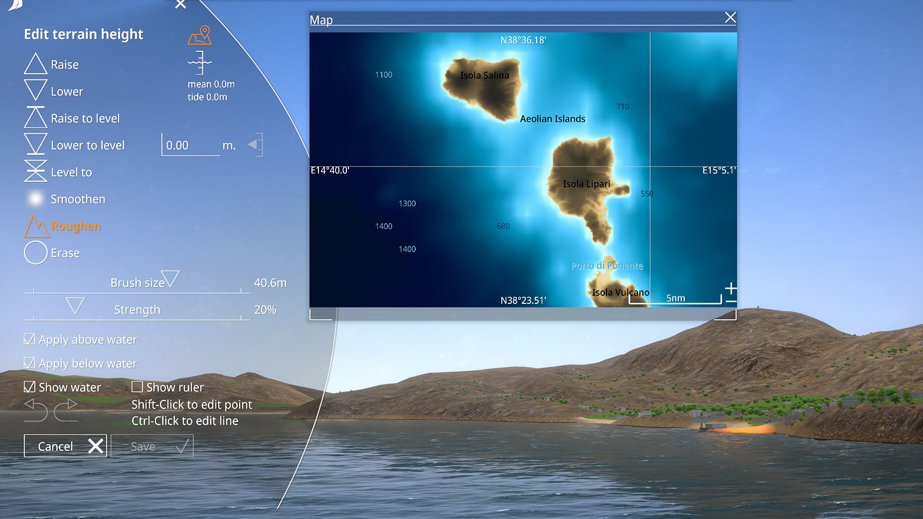
World editor
It's easy to add or edit a sea mark like a buoy or light or the change the water depth in a port. Ports and coastal areas can be edited and decorated with many standard objects or with your own custom models. The intensity of the automatically generated vegetation can be adjusted as well.
But beware: There is only one world. That means your edits are shared with all sailors.
Bubbles
When you purchase Sailaway III, it comes with 2 boat slots. One of them pre-filled with the 38' Cruiser. There is also the free Nordic Folkboat. The 38' cruiser is the perfect boat to undertake great voyages. The Nordisk Folkboat is smaller and easier to handle. A fine boat to learn the basics and get acquainted with the interface. For many people these are all they ever need for their sailing adventures.
If you want to sail other boats or sail more than 2 boats, you can purchase a boat design or a boat slot with bubbles. A bubble is the internal currency of Sailaway. more info...
Steam
Do you have a Steam account? Please go to the Steam Store and put Sailaway III on your wishlist.